Wellsite Navigator
- 4.0
- Rating
- 100.00K
- Installs
- Free
- Price
 Analysis by App-foxy
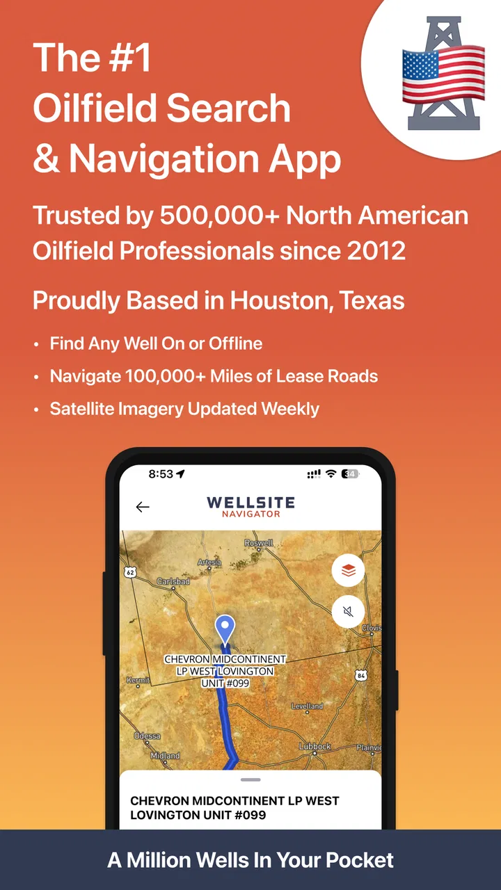
Wellsite Navigator is the kind of app that makes sense only when your work regularly takes you beyond ordinary street addresses. Developed by Wellsite Navigator, LLC, this free Maps & Navigation app is built around finding and routing to wellsites with GPS, rather than helping someone choose a restaurant or avoid a city traffic jam. After spending time with it, I found its appeal fairly immediate: when a location is identified by a wellsite reference instead of a familiar road address, a purpose-built tool feels much more practical than trying to force a general map app to understand the job.
My first impression was that this is a focused work tool, not a casual navigation download. The app is rated for Everyone, runs on Android 8.0 and later, and its current version is 6.7.2. It is free to install, although optional in-app purchases range from $0.99 to $199.99 per item. That combination makes it easy to try, but the real question is not whether it is useful on the first trip. The more important question is whether it remains dependable enough to keep on a working phone after the novelty wears off.
From quick setup to a practical field routine
Before relying on any field-navigation tool, I would make the first test a low-pressure trip and compare the destination with the assignment details already in hand. That gives me a chance to learn how the route reads on my phone and to spot any point where I need local guidance. From there, a repeatable routine matters more than simply getting the app installed.
You May Also Like

 Blood Strike: 2.5 Anniversary
Blood Strike’s Loadouts Turn Every Drop Into a Tactical Gamble
A close look at Blood Strike’s custom loadouts: how fast access to signature weapons reshapes its battle royale rhythm, rewards preparation, and narrows the gap between fights.

 Pandora - Music & Podcasts
Pandora’s Music Is Easy to Start, but Harder to Recover
Pandora’s strength is its low-effort path from a seed to a station. Its weak spot is how much confidence it asks you to place in connection, setup, and quiet recovery.

 8 Ball Pool
 Is Built on Rivalries, Rematches, and Routine
A close look at the rivalries, rematches, shared routines, and unanswered safety questions that turn a quick pool match into a persistent mobile community.

 Samsung Music
’s Quiet Strength Is Playing What You Already Own
Its reach comes less from spectacle than from dependable access to a personal library. That simplicity is both the app’s strongest retention engine and its ceiling.

 AccuWeather: Weather Radar
AccuWeather Review: A Quick, Clear Forecast for Everyday Decisions
For everyday plans, the best forecast is the one you can understand quickly. AccuWeather makes rain timing, radar, and local conditions easy to act on, with a few trade-offs.

 Hill Climb Racing
Why Hill Climb Racing Still Turns Crashes Into One More Run
A tiny car, a bumpy hill and one more upgrade: Hill Climb Racing keeps resurfacing because its simple chaos makes every near-miss feel personal.
More From Our News Desk



Why the first week feels useful
During the first week, the strongest benefit is the change in mindset. Instead of treating a wellsite as an awkward destination that must be translated into a conventional address, I can approach the trip as a location-search and routing task designed for the oilfield. That distinction matters when a driver is dealing with scattered sites, unfamiliar access roads, and destinations that are meaningful to a crew but not necessarily recognizable to a general-purpose navigation service.
The GPS focus also gives the app a clear job. I would use it before leaving the yard to identify the destination, check the proposed route, and make sure the selected site matches the work order or conversation I am following. That small verification step is more important than it sounds. A navigation app can get me moving quickly while still sending me toward the wrong location if I select a similar name or rely on an incomplete description.
For a new user, the best early habit is to treat the first route as preparation rather than blindly following the screen. I would compare the destination with the location details already available to the crew, look at the surrounding road pattern, and note where the route appears to leave ordinary mapped roads. In oilfield travel, the final approach can be more consequential than the highway portion, so a quick review before driving is time well spent.
This is also where Wellsite Navigator separates itself from the usual alternatives. Google Maps, Apple Maps, and similar services are excellent when the destination is a business, house, public facility, or clearly marked road address. They are less naturally suited to a workflow centered on wellsites. A general map may still be useful for the broad journey, but this app is more directly aligned with the question, “How do I reach this specific field location?”
A realistic day on the road
Imagine a field technician receiving a morning assignment with several wellsites spread across an unfamiliar producing area. The technician can use the app to organize the day around actual site destinations instead of manually converting each one into a nearby road name. Before departing, the route can be checked for obvious errors. At each stop, the phone becomes a dedicated navigation reference rather than a mixture of personal messages, unrelated map searches, and browser tabs.
That scenario explains the app’s first-week appeal better than a list of features. Its value is not entertainment or visual polish; it is reducing the translation work between an oilfield location and a usable trip. If your work involves inspections, service calls, deliveries, land access, or repeated visits to producing sites, that focus can make the app feel immediately more relevant than a standard navigation tool.
There is a trade-off, though. A specialist app is only as helpful as the location information you give it and the route it presents. I would not interpret a displayed route as permission to cross a gate, use a private road, or ignore local instructions. The app can help with navigation, but it does not replace site access knowledge, current road conditions, or a company’s safety procedure.
What makes the first month different from the first day
After the initial trial, the question becomes whether the app saves effort repeatedly. In my view, recurring value comes from using it as part of a consistent dispatch routine. Open it when an assignment arrives, verify the site, review the approach, and use it for the trip. That sequence is simple enough to become habitual, which is important for a work app that may be used under time pressure.
The app has reached over 100,000 installs and carries a 4.0 average from around 1,400 ratings, with more than 500 reviews. Those figures suggest that it has found a real audience, but they do not guarantee that every field, region, or workflow will feel equally smooth. I would treat the app as something to test against your own routes rather than assume that popularity alone proves it is the right permanent tool.
For a small operation, the recurring benefit may be consistency. If several people use the same specialized navigation approach, there is less temptation to improvise with screenshots, text descriptions, or loosely remembered nearby landmarks. That does not create a complete dispatch system, but it can make the navigation portion of a job more repeatable.
For an individual contractor, the value is more personal. A dedicated app can reduce the number of steps needed to move from a site reference to a route. The time saved on one trip might be modest, but repeated trips are where a focused tool earns its place. I would judge it over a normal work cycle: does it help me start faster, make fewer destination mistakes, and feel more confident about the final approach?
Maintenance is part of the ownership experience
The maintenance burden is not just installing updates. It includes keeping the phone ready for field use, checking that the app remains compatible with the device, and making sure the navigation workflow still fits current company practice. Because the app is used for work rather than occasional leisure, I would avoid waiting until the morning of a critical trip to discover that I need to sign in, update something, or relearn the interface.
The current version, 6.7.2, indicates that the product has continued through multiple revisions since its release on October 18, 2013. That long presence is reassuring in one sense: this is not a brand-new experiment that appeared yesterday. At the same time, a mature app still deserves regular checking. I would run a test route after a major phone change, system update, or long period without use, especially if the app is being relied on for remote travel.
Another practical maintenance habit is keeping a backup plan. I would not make any single navigation app the only source of direction for a remote job. Carrying the relevant site details through the normal work process and knowing the general route gives me something to fall back on if the phone battery, signal, device, or app creates a problem. That is not a criticism unique to this product; it is sensible field practice, but it matters more here than it would for a short trip across town.
The optional purchase model also deserves attention. The app itself is free, while individual in-app purchases can cost from $0.99 to $199.99. I would review what a paid item provides before approving a purchase, particularly if the phone is company-owned or several workers may need access. The wide range means the financial commitment can be minor or substantial depending on the item, so the free installation should be viewed as an opportunity to evaluate the workflow, not as a promise that every useful capability will remain free.
Where repeated use can become tiring
The main source of fatigue is the narrowness that makes the app valuable in the first place. If I spend most of my time navigating to ordinary addresses, the specialized focus adds little. I would still want a general map app for businesses, urban routing, traffic context, and everyday errands. Keeping two navigation tools can feel inconvenient, especially when switching between them becomes part of every trip.
Another possible frustration is the gap between a mapped destination and the reality on the ground. A route can be logically correct and still leave the driver needing local judgment at the final access point. Gates, changing field conditions, temporary closures, and site-specific instructions are not problems I would expect a GPS app to solve by itself. The right way to use it is as a navigation aid within a larger operational process, not as an authority on whether a road is safe or authorized.
Remote work also exposes the weaknesses of relying heavily on a phone. A bright screen, long route, poor reception, or limited battery can turn a convenient tool into an extra concern. I would start with a charged device, keep the route visible before moving, and avoid making last-second changes while driving. If the app supports the trip well but the surrounding phone habits are careless, the overall experience can still be tiring.
There is also a learning curve for teams. One experienced user may understand how to interpret a wellsite destination quickly, while a new worker may assume that the first suggested route is automatically the correct one. A short internal procedure—confirm the site, inspect the approach, follow access rules, and report uncertainty—would make the app more useful than simply telling everyone to download it.
Who should keep it installed?
I would recommend keeping Wellsite Navigator on the phone if wellsite travel is a regular part of the job. It is especially relevant for field technicians, inspectors, contractors, drivers, and supervisors who repeatedly move between dispersed oilfield locations. The strongest case is not a single emergency trip; it is a pattern of recurring visits where a dedicated wellsite workflow can replace improvised searching.
I would be more cautious for someone who only visits a site once, works mainly in cities, or already has a company navigation system that covers the same destinations with better integration. In those situations, the extra app may create more maintenance and switching than value. The same applies to users who want a general-purpose navigation experience with broad lifestyle features. This app is not trying to be that.
For a team deciding whether to adopt it, I would test several ordinary assignments rather than one easy route. Include a familiar site, an unfamiliar site, and a trip where the final approach requires careful attention. Ask whether the app shortens preparation, whether users interpret destinations consistently, and whether the optional purchase structure fits the budget. That trial will reveal more than the rating alone.
My long-term verdict
Wellsite Navigator earns lasting space when it becomes part of a repeatable field habit. Its strongest quality is its specialization: it treats wellsite navigation as a real use case rather than an awkward variation of ordinary address search. That focus can save mental effort for people whose work genuinely revolves around oilfield locations.
It does not replace judgment, access knowledge, or a general map app. I would keep an alternative available for conventional destinations and maintain a sensible backup plan for remote travel. I would also watch the in-app purchase choices instead of assuming that the free download represents the complete long-term cost.
Still, for the right user, the app’s value should improve rather than disappear after the first week. Once the routine is established, each assignment starts from a familiar place: identify the wellsite, check the route, prepare for the final approach, and navigate with the correct destination in mind. That is a modest promise, but it is a useful one. My final view is that Wellsite Navigator is worth trying for regular oilfield travel, while occasional drivers and general navigation users will probably be better served by the tools they already use.
In short, I see it as a practical specialist rather than an all-purpose replacement. Its free entry point makes evaluation easy, its Everyone rating keeps it broadly accessible, and its long-running development gives it some staying power. The lasting test is simple: after a month of real assignments, does opening it feel like one less problem to solve? For workers who answer yes, Wellsite Navigator has a credible place in the daily toolkit.
FAQs for Wellsite Navigator
01What is Wellsite Navigator used for?
Wellsite Navigator is designed to help oil and gas professionals plan, navigate, and manage access to wellsite locations. It can provide useful location information, mapping support, and field-oriented reference details, making it easier to coordinate visits and find the correct site. Its usefulness may vary depending on the available regional data, device settings, and the specific version installed.
02Does Wellsite Navigator work without an internet connection?
Offline availability is an important consideration for anyone working in remote areas with limited mobile coverage. Wellsite Navigator may offer access to previously loaded or stored information, but users should not assume that every map, well record, or navigation feature will work offline. Before traveling, open the required areas while connected and verify that the app’s current version supports the offline functions you need.
03Is Wellsite Navigator suitable for professional field operations?
The app can be useful for field personnel, contractors, surveyors, and other users who need a practical way to reference wellsite locations and plan travel. However, it should be treated as a supporting tool rather than the only source of operational information. Users should compare its data with company records, official geographic information, access instructions, and current site conditions before making safety or routing decisions.
04What permissions and device features does Wellsite Navigator require?
Depending on the platform and features enabled, Wellsite Navigator may request location access, network connectivity, and permission to use map-related services. Location access is generally needed for navigation or showing your position relative to a wellsite. Review the permissions during installation and in your device settings, and only enable services you are comfortable using. Battery consumption may also increase during continuous GPS use.
05Is Wellsite Navigator free to download and use?
The download price and available features can differ between Android and iOS, as well as between app versions or professional service arrangements. Some functions may be freely accessible while others could require an account, subscription, organizational access, or additional data services. Check the official store listing before downloading for current pricing, in-app purchase details, supported devices, and any requirements that apply to your region.
Pros
- Clear wellsite maps help crews orient themselves quickly in the field.
- Supports faster access to location details during planning and operations.
- Useful for teams working across multiple wellsites and remote areas.
- Can reduce reliance on separate paper maps and manual location notes.
- Designed around practical oilfield workflows rather than general navigation.
Cons
- Coverage and accuracy may depend on available industry data for each region.
- Some features may require an account
- subscription
- or company authorization.
- Remote locations can limit map updates and other online-dependent functions.
- The specialized interface may take time for new oilfield users to learn.
- Not intended as a replacement for certified surveying or emergency navigation tools.

Wellsite Navigator
Gallery